Visually Mapping Pollution: Push for Better Travel

After Shropshire Council announced the use of Earthsense’s air quality service to map pollution levels in the region, Housing Industry Leaders investigates how the sensors work and how the information is collected.
Mapping will deliver real-time information for both particulate matter and nitrogen dioxide. Additionally, it will be available for members of the public to use in Shrewsbury and Bridgnorth.
Using a web application, people and businesses can identify local air qualities. It is expected to be useful for two key reasons. The first is commuters being able to take alternate routes to limit their exposure to polluted areas. This will allow for an improvement in the health and safety of people in the areas.
Secondly, it may provide an incentive for people in Shropshire to travel more sustainably. If people can visualise the levels of pollution in their area, it may convince them to make an active choice to reduce the levels of emissions by travelling on public transport or by foot or bicycle.
The project will use seven sensors and have been strategically placed across the region to ensure the data can be as useful and accurate as possible. These sensor points are placed on a roundabout, a congested junction, a one-way street and multiple street furniture.
Specialised technology allows for the data to be collected in real-time. This enhances the users’ experiences and allows for peak pollution times to be recorded and analysed. Over time, this data can be used to track progress made in the reduction of pollution in the Shropshire area.
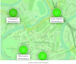
Modelling on a visual map also means there will be an insight into large scale locations that are not monitored by the sensors. This will be specifically beneficial for businesses to track their contributions to pollution.
Cabinet Member for Communities, Place and Planning, Gwilym Butler explained: “The launch of this map is an important step forward in sharing real-time air quality in high pollution areas in Bridgnorth and Shrewsbury.”
Adding to this, Housing Industry Leaders heard: “It allows us to be more open about where high pollution areas are, but also to show residents and businesses how they can make changes to the way they travel.”
As the country pushes towards 2050 net-zero, technologies like this, developed by EarthSense goes a long way to accurately monitoring and aiding the pollution levels.